Alofi
 Niue
Niue
Key facts and a structured country profile. 🧾 Change log 📐 True Size
Locator 🗺️ Map
1,815 (2024 est.)
260 sq km
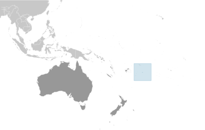
Oceania, island in the South Pacific Ocean, east of Tonga
🧭 Background
Voyagers from Samoa first settled on Niue around A.D. 900, and a second main group of settlers came from Tonga around 1500. With only one reliable source of fresh water, conflict was high on the island. Samoan and Tongan customs heavily influenced Niuean culture, including the formation of an island-wide elected kingship system in the early 1700s. In 1774, British explorer James COOK landed on the island and named it Savage Island because of the Niueans' hostility. Missionaries arrived in 1830 but were also largely unsuccessful at staying on the island until 1846, when a Niuean trained as a Samoan missionary returned to the island and provided a space from which the missionaries could work. In addition to converting the population, the missionaries worked to stop the violent conflicts and helped establish the first parliament in 1849. Great Britain established a protectorate over Niue in 1900. The following year, Niue was annexed to New Zealand and included as part of the Cook Islands. Niue’s remoteness and cultural and linguistic differences with the Cook Islands led New Zealand to separate Niue into its own administration in 1904. The island became internally self-governing in 1974; it is an independent member of international organizations but is in free association with New Zealand, which is responsible for defense and foreign affairs. In September 2023, the US recognized Niue as a sovereign and independent state.
🗺️ Geography
Oceania, island in the South Pacific Ocean, east of Tonga
19 02 S, 169 52 W
Oceania
260 sq km
260 sq km
0 sq km
1.5 times the size of Washington, D.C.
0 km
64 km
12 nm
200 nm
Tropical; modified by southeast trade winds
Steep limestone cliffs along coast, central plateau
Unnamed elevation 1.4 km east of Hikutavake 80 m
Pacific Ocean 0 m
Arable land, fish
18.5% (2023 est.)
Arable land: 3.8% (2023 est.)
Permanent crops: 10.8% (2023 est.)
Permanent pasture: 3.8% (2023 est.)
72.6% (2023 est.)
9% (2023 est.)
0 sq km (2022)
Population distributed around the peripheral coastal areas of the island
Tropical cyclones
One of world's largest coral islands; the only major break in the surrounding coral reef occurs in the central western part of the coast
👥 People and Society⬆️ Top
1,815 (2024 est.)
877 (2024 est.)
938 (2024 est.)
Niuean(s)
Niuean
Niuean 65.4%, part-Niuean 14%, non-Niuean 20.6% (2017 est.)
Niuean 46% (official, a Polynesian language closely related to Tongan and Samoan), Niuean and English 32%, English (official) 11%, Niuean and others 5%, other 6% (2011 est.)
Ekalesia Niue 61.7%, Latter Day Saints 8.7%, Roman Catholic 8.4%, other 8.2%, not stated 5.1%, none 3.7%, Jehovah's Witnesses 2.7%, Seventh Day Adventist 1.4% (2017 est.)
64.6 (2024)
38.2 (2024)
26.4 (2024)
3.8 (2024)
-0.03% (2021 est.)
Population distributed around the peripheral coastal areas of the island
48.2% of total population (2023)
1.43% annual rate of change (2020-25 est.)
1,000 ALOFI (capital) (2018)
71.8 years (2016)
75.7 years (2016 est.)
Total: 97% of population (2022 est.)
Total: 3% of population (2022 est.)
7.8% of GDP (2020)
6.9% of national budget (2022 est.)
Total: 97.4% of population (2022 est.)
Total: 2.6% of population (2022 est.)
50% (2016)
8.5 liters of pure alcohol (2019 est.)
4.28 liters of pure alcohol (2019 est.)
1.89 liters of pure alcohol (2019 est.)
2.33 liters of pure alcohol (2019 est.)
0 liters of pure alcohol (2019 est.)
5.6% national budget (2025 est.)
99.5% (2022 est.)
100% (2022 est.)
100% (2022 est.)
🌿 Environment⬆️ Top
Increasing attention to conservationist practices to counter loss of soil fertility from traditional slash-and-burn agriculture
Biodiversity, Climate Change, Climate Change-Kyoto Protocol, Climate Change-Paris Agreement, Comprehensive Nuclear Test Ban, Desertification, Law of the Sea, Ozone Layer Protection, Ship Pollution
None of the selected agreements
Tropical; modified by southeast trade winds
18.5% (2023 est.)
Arable land: 3.8% (2023 est.)
Permanent crops: 10.8% (2023 est.)
Permanent pasture: 3.8% (2023 est.)
72.6% (2023 est.)
9% (2023 est.)
48.2% of total population (2023)
1.43% annual rate of change (2020-25 est.)
9,000 metric tonnes of CO2 (2023 est.)
9,000 metric tonnes of CO2 (2023 est.)
6.7 micrograms per cubic meter (2019 est.)
🏛️ Government⬆️ Top
None
Niue
Savage Island
The origin of the name is obscure; in Niuean, the word translates as "behold the coconut;" the former name, Savage Island, was the result of an acrimonious meeting in 1774 between English explorer Captain James COOK and local people
Parliamentary democracy
Self-governing in free association with New Zealand since 1974; Niue is fully responsible for internal affairs; under the Niue Constitution Act of 1974, New Zealand provides necessary economic and administrative assistance to Niue, as well as assistance with foreign affairs, defense, and security if requested
Alofi
19 01 S, 169 55 W
UTC-11 (6 hours behind Washington, DC, during Standard Time)
A traditional name for an area of the island; became the name for the newly declared capital in the 20th century
No first-order administrative divisions as defined by the US government, but 14 villages are considered second-order
English common law
Several previous (New Zealand colonial statutes); latest 19 October 1974 (Niue Constitution Act 1974)
Proposed by the Assembly; passage requires at least two-thirds majority vote of the Assembly membership in each of three readings and approval by at least two-thirds majority votes in a referendum; passage of amendments to a number of sections, including Niue’s self-governing status, British nationality and New Zealand citizenship, external affairs and defense, economic and administrative assistance by New Zealand, and amendment procedures, requires at least two-thirds majority vote by the Assembly and at least two thirds of votes in a referendum
18 years of age; universal
King CHARLES III (since 8 September 2022); represented by Governor-General of New Zealand Cindy KIRO (since 21 October 2021); the UK and New Zealand are represented by New Zealand High Commissioner Mark GIBBS (since 5 March 2024)
Prime Minister Dalton TAGELAGI; also referred to as premier (since 10 June 2020)
Cabinet chosen by the prime minister
The monarchy is hereditary; prime minister indirectly elected by the Legislative Assembly for a 3-year term
8 May 2023
Dalton TAGELAGI reelected prime minister; Legislative Assembly vote - Dalton TAGELAGI (independent) 16, O'Love JACOBSEN (independent) 4
2026
Niue Assembly (Fono Ekepule)
Unicameral
20
Plurality/majority
Full renewal
3 years
29 April 2023
Independents (20)
15%
April 2026
Court of Appeal (consists of the chief justice and up to 3 judges)
Niue chief justice appointed by the governor general on the advice of the Cabinet and tendered by the premier; other judges appointed by the governor general on the advice of the Cabinet and tendered by the chief justice and the minister of justice; judges serve until age 68
High Court
None
None (self-governing territory in free association with New Zealand)
None (self-governing territory in free association with New Zealand)
ACP, AOSIS, FAO, IFAD, OPCW, PIF, Sparteca, SPC, UNESCO, UPU, WHO, WIPO, WMO
19 October 1974 (Niue became a self-governing state in free association with New Zealand)
Waitangi Day (Treaty of Waitangi established British sovereignty over New Zealand), 6 February (1840)
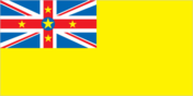
Description: yellow with the UK flag in the upper-left quadrant; the UK flag has five yellow five-pointed stars, with a large star on a blue disk in the center and smaller stars on each arm of the red cross meaning: the large star represents Niue, and the smaller stars symbolize links with New Zealand; yellow stands for sunshine, as well as the warmth and friendship between Niue and New Zealand
Yellow five-pointed star
Yellow
"God Save the King"
Unknown
In use since 1745
💹 Economy⬆️ Top
Upper-middle-income self-governing New Zealand territorial economy; environmentally fragile; massive emigration; post-pandemic tourism rebound; postage stamps, small-scale agricultural processing, and subsistence farming; most recent Asian Development Bank member
$18.7 million (2021 est.)
$19.9 million (2020 est.)
$20.9 million (2019 est.)
$11,100 (2021 est.)
$11,800 (2020 est.)
$12,400 (2019 est.)
Coconuts, taro, fruits, sweet potatoes, tropical fruits, yams, vegetables, lemons/limes, bananas, pork (2023)
Handicrafts, food processing
USA 54%, Germany 8%, Canada 5%, UK 5%, Guatemala 4% (2023)
Abrasive powder, coin (2023)
NZ 87%, Fiji 6%, UAE 2%, Slovakia 1%, Australia 1% (2023)
Refined petroleum, plastic products, machine parts, construction vehicles, cars (2023)
New Zealand dollars (NZD) per US dollar -
1.652 (2024 est.)
1.628 (2023 est.)
1.577 (2022 est.)
1.414 (2021 est.)
1.542 (2020 est.)
⚡ Energy⬆️ Top
3,000 kW (2023 est.)
3 million kWh (2023 est.)
400,000 kWh (2023 est.)
100% of total installed capacity (2023 est.)
61 bbl/day (2023 est.)
📡 Communications⬆️ Top
1,000 (2021 est.)
52 (2021 est.)
1 state-owned TV station, with many of the programs supplied by Television New Zealand; 1 state-owned radio station broadcasting in AM and FM (2019)
.nu
80% (2024 est.)
🚚 Transportation⬆️ Top
1 (2025)
70 (2023)
Bulk carrier 5, container ship 2, general cargo 29, oil tanker 4, other 30
1 (2024)
0
0
0
1
0
Alofi
🛡️ Military and Security⬆️ Top
No regular indigenous military forces; Niue Police Department
Under the Niue Constitution Act of 1974, New Zealand provides assistance with foreign affairs, defense, and security if requested by the Niue government
Source: Factbook JSON archive.