Uninhabited
 Heard Island and McDonald Islands
Key facts and a structured country profile. 🧾 Change log 📐 True Size
Locator 🗺️ Map
412 sq km
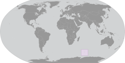
Islands in the Indian Ocean, about two-thirds of the way from Madagascar to Antarctica
🧭 Background
American sailor John HEARD discovered Heard Island in 1853 while fellow American William MCDONALD discovered the McDonald Islands the following year. Starting in 1855, sealers lived on the islands and harvested elephant seal oil; by the time the practice was ended in 1877, most of the islands’ seals were killed. The UK formally claimed the islands in 1910, and Australian explorer Douglas MAWSON visited Heard Island in 1929. In 1947, the UK transferred the islands to Australia for its Antarctica research, but Australia closed the research station on Heard Island in 1954 when it opened a new research station on the Antarctic continent. McDonald Island has been an active volcano since it emerged from dormancy in 1992, and the island doubled in size after an eruption in 1996. In 1997, the islands were named a UNESCO World Heritage site. Populated by a large number of bird species, seals, and penguins, the islands are primarily used for research, with limited fishing permitted in the surrounding waters.
🗺️ Geography
Islands in the Indian Ocean, about two-thirds of the way from Madagascar to Antarctica
53 06 S, 72 31 E
Antarctic Region
412 sq km
412 sq km
0 sq km
Slightly more than two times the size of Washington, D.C.
0 km
101.9 km
12 nm
200 nm
Antarctic
Heard Island - 80% ice-covered, bleak and mountainous, dominated by a large massif (Big Ben) and an active volcano (Mawson Peak); McDonald Islands - small and rocky
Mawson Peak on Big Ben volcano 2,745 m
Indian Ocean 0 m
Fish
0% (2011 est.)
100% (2018 est.)
Mawson Peak, an active volcano, is on Heard Island
Mawson Peak on Heard Island is the highest Australian mountain; at 2,745 m (9,006 ft), Mawson is taller than Mt. Kosciuszko in mainland Australia), and one of only two active volcanoes located in Australian territory; in 1992, McDonald Island, the other active volcano, broke its dormancy and began erupting; it has erupted several times since
👥 People and Society⬆️ Top
Uninhabited
🌿 Environment⬆️ Top
Antarctic
0% (2011 est.)
100% (2018 est.)
🏛️ Government⬆️ Top
Territory of Heard Island and McDonald Islands
Heard Island and McDonald Islands
HIMI
Named after US Captain John HEARD, who sighted the island on 25 November 1853, and US Captain William McDONALD, who discovered the islands on 4 January 1854
Territory of Australia; administered from Canberra by the Department of Agriculture, Water, and the Environment (Australian Antarctic Division)
The laws of Australia apply
None (territory of Australia)
None (territory of Australia)
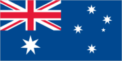
The flag of Australia is used
1 (natural); note - excerpted from the Australia entry
Heard Island and McDonald Islands
📡 Communications⬆️ Top
.hm
🚚 Transportation⬆️ Top
2 (2025)
🛡️ Military and Security⬆️ Top
Defense is the responsibility of Australia
Source: Factbook JSON archive.