West Island
 Cocos (Keeling) Islands
Key facts and a structured country profile. 🧾 Change log 📐 True Size
Locator 🗺️ Map
593 (2021 est.)
14 sq km
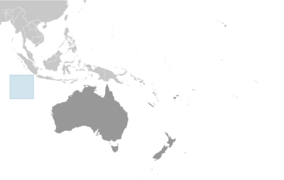
Southeastern Asia, group of islands in the Indian Ocean, southwest of Indonesia, about halfway between Australia and Sri Lanka
🧭 Background
British sea captain William KEELING discovered the Cocos (Keeling) Islands in 1609, and they were named for their coconut trees in 1622. Some maps began referring to them as the Keeling Islands in 1703. In 1825, Scottish trader John CLUNIES-ROSS was trying to get to Christmas Island but was blown off course and landed on Cocos (Keeling) Islands. The next year, a British trader hired CLUNIES-ROSS's brother to bring slaves and a harem of Malay women to create the first permanent settlement on the island. By the 1830s, the Clunies-Ross family had firmly established themselves as the leaders of the islands, and they ruled Cocos (Keeling) Islands in a feudal style until 1978. The UK annexed the islands in 1857 and administered them from Ceylon after 1878 and from Singapore after 1886. The Cocos (Keeling) Islands hosted a cable relaying station and was attacked by the Germans in World War I. The Japanese similarly attacked the islands in World War II. The UK transferred the islands to Australia in 1955, when they were officially named the Cocos (Keeling) Islands, and in 1978, Australia bought all the land held by the Clunies-Ross family, ending their control of the islands. In a referendum in 1984, most islanders voted to integrate with Australia, and Western Australian laws have applied on the islands since 1992.
🗺️ Geography
Southeastern Asia, group of islands in the Indian Ocean, southwest of Indonesia, about halfway between Australia and Sri Lanka
12 30 S, 96 50 E
Southeast Asia
14 sq km
14 sq km
0 sq km
About 24 times the size of the National Mall in Washington, D.C.
0 km
26 km
12 nm
200 nm
Tropical with high humidity, moderated by the southeast trade winds for about nine months of the year
Flat, low-lying coral atolls
South Point on South Island 9 m
Indian Ocean 0 m
Fish
0% (2018 est.)
0% (2018 est.)
100% (2018 est.)
NA
Only Home Island and West Island are populated
Cyclone season is October to April
There are 27 coral islands in the group; apart from North Keeling Island, which lies 30 km north of the main group, the islands form a horseshoe-shaped atoll around a lagoon
👥 People and Society⬆️ Top
593 (2021 est.)
301
292
Cocos Islander(s)
Cocos Islander
Europeans, Cocos Malays
Malay (Cocos dialect) 68.8%, English 22.3%, unspecified 8.9%; note - data represent language spoken at home (2016 est.)
Buku Fakta Dunia, sumber yang diperlukan untuk maklumat asas. (Malay) The World Factbook, the indispensable source for basic information.
Muslim (predominantly Sunni) 75%, Anglican 3.5%, Roman Catholic 2.2%, none 12.9%, unspecified 6.3% (2016 est.)
21.2%
61.5%
17.3% (2021)
40 years (2021 est.)
8.89 deaths/1,000 population (2021 est.)
Only Home Island and West Island are populated
🌿 Environment⬆️ Top
Limited freshwater resources; illegal fishing
Tropical with high humidity, moderated by the southeast trade winds for about nine months of the year
0% (2018 est.)
0% (2018 est.)
100% (2018 est.)
🏛️ Government⬆️ Top
Territory of Cocos (Keeling) Islands
Cocos (Keeling) Islands
The name refers to the abundant coconut trees on the islands and to English Captain William KEELING, the first European to sight the islands in 1609
Non-self-governing overseas territory of Australia
Non-self-governing territory of Australia; administered from Canberra by the Department of Infrastructure, Transport, Cities & Regional Development
West Island
12 10 S, 96 50 E
UTC+6.5 (11.5 hours ahead of Washington, DC, during Standard Time)
Common law based on the Australian model
23 November 1955 (Cocos (Keeling) Islands Act 1955)
See Australia
18 years of age
King CHARLES III (since 8 September 2022); represented by Governor-General of the Commonwealth of Australia General Sam MOSTYN (since 1 July 2024)
Administrator Farzian ZAINAL (since 11 May 2023)
NA
The monarchy is hereditary; governor general appointed by the monarch on the recommendation of the Australian prime minister; administrator appointed by the governor-general for a 2-year term and represents the monarch and Australia
Cocos (Keeling) Islands Shire Council
Unicameral
7 (directly elected)
Plurality/majority
Partial renewal
4 years
10/21/2023
16.7%
October 2025
Under the terms of the Territorial Law Reform Act 1992, Western Australia provides court services as needed for the island including the Supreme Court and subordinate courts (District Court, Magistrate Court, Family Court, Children's Court, and Coroners' Court)
None
None (territory of Australia)
None (territory of Australia)
None
None (territory of Australia)
Australia Day (commemorates the arrival of the First Fleet of Australian settlers), 26 January (1788)
The flag of Australia is used
"God Save the King"
Unknown
Royal anthem, as an Australian territory
💹 Economy⬆️ Top
Vegetables, bananas, pawpaws, coconuts
Copra products, tourism
USA 31%, Singapore 29%, UK 12%, Australia 3%, Brazil 3% (2023)
Ships (2023)
Australia 87%, USA 3%, Philippines 2%, Sweden 2%, Brazil 1% (2023)
Iron structures, special purpose motor vehicles, cars, ships, aluminum structures (2023)
Australian dollars (AUD) per US dollar -
1.515 (2024 est.)
1.505 (2023 est.)
1.442 (2022 est.)
1.331 (2021 est.)
1.453 (2020 est.)
📡 Communications⬆️ Top
1 local radio station staffed by community volunteers; satellite broadcasts of several Australian radio and TV stations available (2017)
.cc
13.4% (2021 est.)
🚚 Transportation⬆️ Top
1 (2025)
🛡️ Military and Security⬆️ Top
Defense is the responsibility of Australia
Source: Factbook JSON archive.