Jamestown
 Saint Helena, Ascension, and Tristan da Cunha
Key facts and a structured country profile. 🧾 Change log 📐 True Size
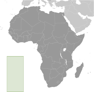
Locator 🗺️ Map
7,943 (2024 est.)
394 sq km
Islands in the South Atlantic Ocean, about midway between South America and Africa; Ascension Island lies 1,300 km (800 mi) northwest of Saint Helena; Tristan da Cunha lies 4,300 km (2,700 mi) southwest of Saint Helena
🧭 Background
Saint Helena is a British Overseas Territory off the coast of Africa in the South Atlantic Ocean, and it consists of Saint Helena, Ascension Island, and the island group of Tristan da Cunha. Saint Helena: The island was uninhabited when the Portuguese first discovered it in 1502, and the British garrisoned troops on Saint Helena during the 17th century. It acquired fame as the place of Napoleon BONAPARTE's exile from 1815 until his death in 1821, but its importance as a port of call declined after the opening of the Suez Canal in 1869. During the Anglo-Boer War in South Africa, several thousand Boer prisoners were confined on the island between 1900 and 1903. Saint Helena is one of the most remote populated places in the world. The British Government committed to building an airport on Saint Helena in 2005. After more than a decade of delays and construction, a commercial air service to South Africa via Namibia was inaugurated in 2017. The weekly service to Saint Helena from Johannesburg via Windhoek in Namibia takes just over six hours (including the refueling stop in Windhoek) and replaces the mail ship that had made a five-day journey to the island every three weeks. Ascension Island: This barren and uninhabited island was discovered and named by the Portuguese in 1503. The British garrisoned the island in 1815 to prevent a rescue of NAPOLEON from Saint Helena. It served as a provisioning station for the Royal Navy's West Africa Squadron on anti-slavery patrol. The island remained under Admiralty control until 1922, when it became a dependency of Saint Helena. During World War II, the UK permitted the US to construct an airfield on Ascension in support of transatlantic flights to Africa and anti-submarine operations in the South Atlantic. In the 1960s, the island became an important space tracking station for the US. In 1982, Ascension was an essential staging area for British forces during the Falklands War. It remains a critical refueling point in the air-bridge from the UK to the South Atlantic. The island hosts one of four dedicated ground antennas that assist in the operation of the Global Positioning System (GPS) navigation system -- the others are on Diego Garcia (British Indian Ocean Territory), Kwajalein (Marshall Islands), and at Cape Canaveral, Florida (US). NASA and the US Air Force also operate a Meter-Class Autonomous Telescope (MCAT) on Ascension as part of the deep space surveillance system for tracking orbital debris, which can be a hazard to spacecraft and astronauts. Tristan da Cunha: The island group consists of Tristan da Cunha, Nightingale, Inaccessible, and Gough Islands. Tristan da Cunha, named after its Portuguese discoverer (1506), was garrisoned by the British in 1816 to prevent any attempt to rescue NAPOLEON from Saint Helena. Gough and Inaccessible Islands have been designated World Heritage Sites. South Africa leases a site for a meteorological station on Gough Island.
🗺️ Geography
Islands in the South Atlantic Ocean, about midway between South America and Africa; Ascension Island lies 1,300 km (800 mi) northwest of Saint Helena; Tristan da Cunha lies 4,300 km (2,700 mi) southwest of Saint Helena
Saint Helena: 15 57 S, 5 42 W Ascension Island: 7 57 S, 14 22 W Tristan da Cunha island group: 37 15 S, 12 30 W
Africa
394 sq km
122 sq km Saint Helena Island
0 sq km
Slightly more than twice the size of Washington, D.C.
0 km
Saint Helena: 60 km Ascension Island: NA Tristan da Cunha (island only): 34 km
12 nm
200 nm
Saint Helena: tropical marine; mild, tempered by trade winds Ascension Island: tropical marine; mild, semi-arid Tristan da Cunha: temperate marine; mild, tempered by trade winds (tends to be cooler than Saint Helena)
The islands of this group are of volcanic origin associated with the Atlantic Mid-Ocean Ridge Saint Helena: rugged, volcanic; small scattered plateaus and plains Ascension: surface covered by lava flows and cinder cones of 44 dormant volcanoes; terrain rises to the east Tristan da Cunha: sheer cliffs line the coastline of the nearly circular island; the flanks of the central volcanic peak are deeply dissected; narrow coastal plain lies between The Peak and the coastal cliffs
Queen Mary's Peak on Tristan da Cunha 2,060 m; Green Mountain on Ascension Island 859 m; Diana's Peak on Saint Helena Island 818 m
Atlantic Ocean 0 m
Fish, lobster
30.8% (2022 est.)
Arable land: 10.3% (2022 est.)
Permanent crops: 0% (2022 est.)
Permanent pasture: 20.5% (2022 est.)
5.1% (2022 est.)
64.1% (2022 est.)
0 sq km (2022)
Saint Helena: population is concentrated in and around the capital of Jamestown in the northwest, with another significant cluster in the interior Longwood area Ascension: most of the population lives in and around Georgetown Tristan da Cunha: most of the nearly 300 inhabitants live in the northern coastal town of Edinburgh of the Seven Seas
Active volcanism volcanism: the volcanoes of Tristan da Cunha (2,060 m) and Nightingale Island (365 m) are active
Saint Helena harbors at least 40 species of plants unknown elsewhere in the world; Ascension is a breeding ground for sea turtles and sooty terns; Queen Mary's Peak on Tristan da Cunha is the highest island mountain in the South Atlantic and a prominent landmark on the sea lanes around southern Africa
👥 People and Society⬆️ Top
7,943 (2024 est.)
3,978
3,965
Saint Helenian(s)
Saint Helenian
St. Helena 82.1%, UK 7.6%, South Africa 3.6%, Ascension 2.8%, other 3.9% (2021 est.)
English
Anglican 63.2%, unspecified 11.4%, no religion 9%, Jehovah's Witness 3.8%, Baptist 2.3%, Salvation Army 2%, Roman Catholic 2.2%, Seventh Day Adventist 1.9%, New Apostolic 1.6%, other Christian 1.4%, other 1.1% (2021 est.)
14.3% (male 579/female 556)
66.5% (male 2,626/female 2,655)
19.2% (2024 est.) (male 773/female 754)
50.4 (2024 est.)
21.5 (2024 est.)
28.9 (2024 est.)
3.5 (2024 est.)
45.5 years (2025 est.)
44.8 years
45.4 years
0.08% (2025 est.)
9.31 births/1,000 population (2025 est.)
8.55 deaths/1,000 population (2025 est.)
0 migrant(s)/1,000 population (2025 est.)
Saint Helena: population is concentrated in and around the capital of Jamestown in the northwest, with another significant cluster in the interior Longwood area Ascension: most of the population lives in and around Georgetown Tristan da Cunha: most of the nearly 300 inhabitants live in the northern coastal town of Edinburgh of the Seven Seas
40.7% of total population (2023)
0.98% annual rate of change (2020-25 est.)
1,000 JAMESTOWN (capital) (2018)
1.06 male(s)/female
1.04 male(s)/female
0.99 male(s)/female
1.03 male(s)/female
1 male(s)/female (2024 est.)
17.5 deaths/1,000 live births (2025 est.)
21.7 deaths/1,000 live births
14.2 deaths/1,000 live births
80.9 years (2024 est.)
78.1 years
83.9 years
1.61 children born/woman (2025 est.)
0.79 (2025 est.)
Total: 99.1% of population (2022 est.)
Total: 0.9% of population (2022 est.)
Total: 100% of population (2022 est.)
Total: 0% of population (2022 est.)
🌿 Environment⬆️ Top
Development threatens wildlife on Saint Helena
Saint Helena: tropical marine; mild, tempered by trade winds Ascension Island: tropical marine; mild, semi-arid Tristan da Cunha: temperate marine; mild, tempered by trade winds (tends to be cooler than Saint Helena)
30.8% (2022 est.)
Arable land: 10.3% (2022 est.)
Permanent crops: 0% (2022 est.)
Permanent pasture: 20.5% (2022 est.)
5.1% (2022 est.)
64.1% (2022 est.)
40.7% of total population (2023)
0.98% annual rate of change (2020-25 est.)
12,000 metric tonnes of CO2 (2023 est.)
12,000 metric tonnes of CO2 (2023 est.)
🏛️ Government⬆️ Top
Saint Helena, Ascension, and Tristan da Cunha
None
On the feast day of Saint Helena in 1502, Spanish navigator Joao da NOVA (sailing for Portugal) sighted and named the island that now bears the saint's name; da NOVA originally named Ascension "Conception Island" in honor of the Virgin Mary, but Portuguese navigator Afonso de ALBUQUERQUE later found the island on the feast day of the Ascension in 1508 and renamed it; Portuguese explorer Tristao da CUNHA sighted the third island in 1506 and named it after himself (the name was later anglicized)
Parliamentary democracy
Overseas territory of the UK
Jamestown
15 56 S, 5 43 W
UTC 0 (5 hours ahead of Washington, DC, during Standard Time)
Founded in 1659 and named after James, Duke of York, who would become King JAMES II of England
3 administrative areas; Ascension, Saint Helena, Tristan da Cunha
English common law and local statutes
Several previous; latest effective 1 September 2009 (St. Helena, Ascension and Tristan da Cunha Constitution Order 2009)
See United Kingdom
18 years of age
King CHARLES III (since 8 September 2022)
Governor Nigel PHILLIPS (since 13 August 2022)
Executive Council consists of the governor, 3 ex-officio officers, and 5 elected members of the Legislative Council
None; the monarchy is hereditary; governor appointed by the monarch
Court of Appeal (consists of the court president and 2 justices); Supreme Court (consists of the chief justice and judges)
Court of Appeal and Supreme Court justices appointed by the governor acting upon the instructions from a secretary of state acting on behalf of the British monarch; justices of both courts serve until retirement at age 70, but terms can be extended
Magistrates' Court; Small Claims Court; Juvenile Court
None
None (overseas territory of the UK)
None (overseas territory of the UK)
UPU
None (overseas territory of the UK)
Official birthday of King Charles III, celebrated in April or June as designated by the governor (1948)
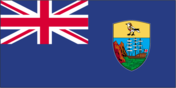
Description: blue with the UK flag in the upper-left quadrant and the Saint Helenian shield centered on the right half of the flag; the upper third of the shield depicts a white plover on a yellow field; under the bird is a rocky coastline and a three-masted sailing ship with sails furled and flying an English flag history: the flag has been in use since 1984, when it was commissioned to mark the 150th anniversary of Saint Helena becoming a Crown Colony
Saint Helena plover (wire bird)
The coat of arms of Saint Helena was officially granted on January 30, 1984; the national bird, the Saint Helena plover (Charadrius sanctaehelenae), is at the top of the shield; the lower part of the shield shows a three-masted sailing ship with the mountainous island to the left; below the shield is a scroll with the motto “Loyal and unshakable;” the crest shows an image of Saint Helena, holding a cross and a flower
"God Save the King"
Unknown
Official anthem, as a UK overseas territory
💹 Economy⬆️ Top
Upper middle-income, British Atlantic Ocean territorial economy; native (but pegged to British pound) currency user on 2 of 3 islands; significant UK financial support; unique land/farming commune structure; military-related economic activity; sport fishing locale
Coffee, corn, potatoes, vegetables; fish, lobster; livestock; timber
Construction, crafts (furniture, lacework, fancy woodwork), fishing, collectible postage stamps
Singapore 33%, USA 16%, Japan 10%, Turkey 10%, Senegal 8% (2023)
Fish, shellfish, natural gas, trucks, construction vehicles (2023)
UK 34%, Greece 26%, Spain 16%, South Africa 15%, Namibia 2% (2023)
Refined petroleum, baked goods, plastic products, vehicle parts/accessories, air pumps (2023)
Saint Helena pounds (SHP) per US dollar -
0.805 (2023 est.)
0.811 (2022 est.)
0.727 (2021 est.)
0.78 (2020 est.)
0.783 (2019 est.)
⚡ Energy⬆️ Top
100% (2021)
5,000 kW (2023 est.)
6.962 million kWh (2023 est.)
1.5 million kWh (2023 est.)
100% of total installed capacity (2023 est.)
70 metric tons (2022 est.)
85 bbl/day (2023 est.)
📡 Communications⬆️ Top
4,000 (2021 est.)
74 (2021 est.)
4,000 (2021 est.)
74 (2021 est.)
Saint Helena: no local TV station; 2 local radio stations, one of which is relayed to Ascension Island; satellite TV stations rebroadcast terrestrially Ascension Island: no local TV station; 1 local radio station and receives relays of broadcasts from radio station on Saint Helena; broadcasts from the British Forces Broadcasting Service (BFBS) available, as well as US military TV Tristan da Cunha: 1 local radio station and receives BFBS TV and radio broadcasts
.sh
37.6% (2021 est.)
1,000 (2018 est.)
17 (2020 est.)
🚚 Transportation⬆️ Top
VQ-H
2 (2025)
2 (2025)
4 (2024)
1
1
1
1
2
Edinburgh of the Seven Seas, Georgetown, Jamestown, North Point
The new airport on Saint Helena opened for limited operations in 2016, and the first commercial flight took place in 2017; the military airport on Ascension Island is closed to civilian traffic; there is no air connection to Tristan da Cunha and very limited sea connections
🛡️ Military and Security⬆️ Top
Defense is the responsibility of the UK
Source: Factbook JSON archive.