Kingston
 Norfolk Island
Key facts and a structured country profile. 🧾 Change log 📐 True Size
Locator 🗺️ Map
1,739 (2021)
36 sq km
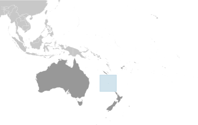
Oceania, island in the South Pacific Ocean, east of Australia
🧭 Background
Polynesians lived on Norfolk Island between 1200 and 1500, but the remote island was uninhabited by the time British explorer James COOK landed on the island in 1774. Two British attempts at establishing the island as a penal colony (1788-1814 and 1825-55) were ultimately abandoned. In 1856, almost 200 Pitcairn Islanders -- descendants of the Bounty mutineers and their Tahitian companions -- were relocated to Norfolk Island because of overcrowding on the Pitcairn Islands. Some returned to the Pitcairn Islands over the next few years, but most settled permanently on Norfolk Island and recreated their previous land tenure and governance structures. Norfolk Island retained a great degree of local control until 1897, when it became a dependency of New South Wales. During World War II, Norfolk Island was an airbase and an important refueling stop in the South Pacific. In 1976, an Australian judge recommended Norfolk Island be incorporated fully into Australia, which Norfolk Islanders rejected. After an appeal to the UN, Australia granted limited self-government to Norfolk Island in 1979. With growing financial troubles during the 2000s, Australia abolished the Norfolk Island Legislative Assembly in 2015, reduced Norfolk Island’s autonomy in 2016, and suspended the local council in 2020. Most services are provided by a mix of the Australian Capital Territory and the states of New South Wales and Queensland. These moves were unpopular on Norfolk Island, which has sought to have its self-government restored and as of 2024, the Australian Government was working with Norfolk Island to establish a new local governing body.
🗺️ Geography
Oceania, island in the South Pacific Ocean, east of Australia
29 02 S, 167 57 E
Oceania
36 sq km
36 sq km
0 sq km
About 0.2 times the size of Washington, D.C.
0 km
32 km
12 nm
24 nm
200 nm
Subtropical; mild, little seasonal temperature variation
Volcanic island with mostly rolling plains
Mount Bates 319 m
Pacific Ocean 0 m
Fish
25% (2023 est.)
Arable land: 0% (2022 est.)
Permanent crops: 0% (2022 est.)
Permanent pasture: 25% (2023 est.)
12.2% (2023 est.)
62.8% (2023 est.)
0 sq km (2022)
Population concentrated around the capital of Kingston
Tropical cyclones (especially May to July)
Most of the 32-km (20-mi) coastline consists of almost inaccessible cliffs, but the land slopes down to the sea in one small southern area on Sydney Bay, where the capital of Kingston is located
👥 People and Society⬆️ Top
1,739 (2021)
823
916
Norfolk Islander(s)
Norfolk Islander(s)
Australian 22.8%, English 22.4%, Pitcairn Islander 20%, Scottish 6%, Irish 5.2% (2011 est.)
English (official) 44.9%, Norfolk (official, a mixture of 18th century English and ancient Tahitian) 40.3%, Fijian 1.8%, other 6.8%, unspecified 6.2% (2016 est.)
Protestant 46.8% (Anglican 29.2%, Uniting Church in Australia 9.8%, Presbyterian 2.9%, Seventh Day Adventist 2.7%, other 2.2%), Roman Catholic 12.6%, other Christian 2.9%, other 1.4%, none 26.7%, unspecified 9.5% (2016 est.)
0.01% (2014 est.)
Population concentrated around the capital of Kingston
🌿 Environment⬆️ Top
Inadequate solid-waste management; most freshwater obtained through rainwater catchment; preservation of unique ecosystem
Subtropical; mild, little seasonal temperature variation
25% (2023 est.)
Arable land: 0% (2022 est.)
Permanent crops: 0% (2022 est.)
Permanent pasture: 25% (2023 est.)
12.2% (2023 est.)
62.8% (2023 est.)
🏛️ Government⬆️ Top
Territory of Norfolk Island
Norfolk Island
Named by British explorer Captain James COOK after Edward HOWARD, the ninth Duke of Norfolk, in 1774
Administered as an overseas territory of Australia
Administered as a territory of Australia; administered by the Australian Government through the Department of Infrastructure, Transport, Cities, & Regional Development
Kingston
29 03 S, 167 58 E
UTC+11 (16 hours ahead of Washington, DC, during Standard Time)
+1hr, begins first Sunday in October; ends first Sunday in April
The name blends the words "king's" and "town;" the English king at the time of the town's settlement in the late 18th century was GEORGE III
English common law and the laws of Australia
Previous 1913, 1957; latest effective 7 August 1979
See Australia
18 years of age; universal
King CHARLES III (since 8 September 2022); represented by Governor General of the Commonwealth of Australia General Sam MOSTYN (since 1 July 2024)
Administrator George PLANT (since 1 June 2023)
The monarchy is hereditary; governor general appointed by the monarch; administrator appointed by the governor general of Australia for a 2-year term and represents the monarch and Australia
Norfolk Island Regional Council
Unicameral
5 (directly elected)
Plurality/majority
Full renewal
4 years
5/28/2016
Independent (5)
20%
March 2021 (postponed)
Supreme Court of Norfolk Island (consists of the chief justice and several justices)
Justices appointed by the governor general of Australia from among justices of the Federal Court of Australia; justices serve until mandatory retirement at age 70
Petty Court of Sessions; specialized courts, including a Coroner's Court and the Employment Tribunal
Norfolk Island Labor Party Norfolk Liberals
None (territory of Australia)
None (territory of Australia)
UPU
None (territory of Australia)
Bounty Day (commemorates the arrival of Pitcairn Islanders), 8 June (1856)
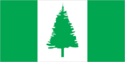
Description: three vertical bands of green (left side), white, and green, with a large green Norfolk Island pine tree centered on the white band meaning: green stands for the island's rich vegetation, and the native pine tree is an island symbol
Norfolk Island pine
Norfolk Island is part of the Commonwealth of Australia, and in 1980, Queen Elizabeth II granted it a separate coat of arms (pictured); in the center is the island’s symbol, the Norfolk Island Pine, with Britain’s lion and Australia’s kangaroo supporting the shield; the island’s motto, “Inasmuch,” comes from a verse in the Bible’s Gospel of Matthew
"God Save the King"
Unknown
Royal anthem, as an Australian overseas territory
💹 Economy⬆️ Top
High-income Australian territorial economy; key tourism and re-exportation industries; small labor force and declining participation creating more part-time jobs; former tax haven; increasing medical cannabis exporter; little transportation infrastructure
Norfolk Island pine seed, Kentia palm seed, cereals, vegetables, fruit; cattle, poultry
Tourism, light industry, ready mixed concrete
USA 31%, Belgium 9%, Philippines 7%, Israel 6%, Singapore 6% (2023)
Pine seeds, lumber, cars and vehicle parts, soybeans, lactose syrup (2021)
Australia 52%, Fiji 13%, NZ 12%, Saudi Arabia 12%, Malaysia 5% (2023)
Refined petroleum, plastics, electrical lighting/signalling equipment, cars, machinery (2023)
Australian dollars (AUD) per US dollar -
1.515 (2024 est.)
1.505 (2023 est.)
1.442 (2022 est.)
1.331 (2021 est.)
1.453 (2020 est.)
📡 Communications⬆️ Top
1 local radio station; broadcasts of several Australian radio and TV stations available via satellite (2009)
.nf
46.1% (2021 est.)
🚚 Transportation⬆️ Top
1 (2025)
1 (2024)
0
0
0
1
1
Kingston
🛡️ Military and Security⬆️ Top
Defense is the responsibility of Australia
Source: Factbook JSON archive.