Uninhabited
 Navassa Island
Key facts and a structured country profile. 🧾 Change log 📐 True Size
Locator 🗺️ Map
5 sq km
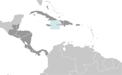
Caribbean, island in the Caribbean Sea, 30 nm west of Tiburon Peninsula of Haiti
🧭 Background
The US claimed uninhabited Navassa Island in 1857 for its guano. Mining took place between 1865 and 1898. The lighthouse, built in 1917, was shut down in 1996, and administration of Navassa Island was transferred from the US Coast Guard to the Department of the Interior, Office of Insular Affairs. A 1998 scientific expedition to the island described it as a "unique preserve of Caribbean biodiversity." The following year it became a National Wildlife Refuge, and annual scientific expeditions have continued.
🗺️ Geography
Caribbean, island in the Caribbean Sea, 30 nm west of Tiburon Peninsula of Haiti
18 25 N, 75 02 W
Central America and the Caribbean
5 sq km
5.4 sq km
0 sq km
About nine times the size of the National Mall in Washington, D.C.
0 km
8 km
12 nm
200 nm
Marine, tropical
Raised flat to undulating coral and limestone plateau; ringed by vertical white cliffs (9 to 15 m high)
200 m NNW of lighthouse 85 m
Caribbean Sea 0 m
Guano (mining discontinued in 1898)
100% (2018 est.)
Hurricanes
Strategic location 160 km south of the US Naval Base at Guantanamo Bay, Cuba; mostly exposed rock with numerous solution holes (limestone sinkholes) but with enough grassland to support goat herds; dense stands of fig trees, scattered cactus
👥 People and Society⬆️ Top
Uninhabited
🌿 Environment⬆️ Top
Some coral bleaching
Marine, tropical
100% (2018 est.)
🏛️ Government⬆️ Top
None
Navassa Island
The flat island was named "Navaza" by sailors with the Christopher COLUMBUS expedition in 1504; the name derives from the Spanish word nava, meaning "flat land or level ground"
Unorganized, unincorporated territory of the US; administered by the Fish and Wildlife Service, US Department of the Interior, from the Caribbean Islands National Wildlife Refuge in Boqueron, Puerto Rico; Haiti has claimed the island since the 19th century
The laws of the US apply
None (territory of the US)
The flag of the US is used
🛡️ Military and Security⬆️ Top
Defense is the responsibility of the US
Source: Factbook JSON archive.