Torshavn
 Faroe Islands
Key facts and a structured country profile. 🧾 Change log 📐 True Size
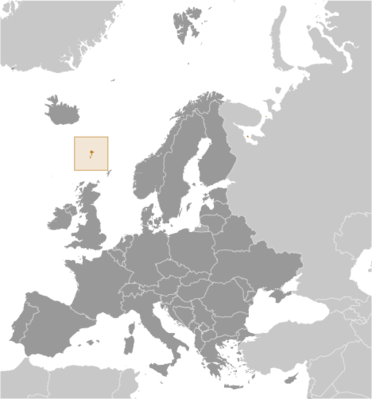
Locator 🗺️ Map
52,933 (2024 est.)
1,393 sq km
Northern Europe, island group between the Norwegian Sea and the North Atlantic Ocean, about halfway between Iceland and Norway
🧭 Background
The Faroe Islands were already populated by about A.D. 500, but whether the original settlers were Celtic or early Norse (or someone else) has yet to be determined. Viking settlers arrived on the islands in the 9th century, and the islands served as an important stepping stone for medieval Viking exploration of the North Atlantic. The islands have been connected politically to Denmark since the 14th century, and today the Faroe Islands are a self-governing dependency of Denmark. The Home Rule Act of 1948 granted a high degree of self-government to the Faroese, who have autonomy over most internal affairs and external trade, while Denmark is responsible for justice, defense, and some foreign affairs. The Faroe Islands are not part of the European Union.
🗺️ Geography
Northern Europe, island group between the Norwegian Sea and the North Atlantic Ocean, about halfway between Iceland and Norway
62 00 N, 7 00 W
Europe
1,393 sq km
1,393 sq km
0 sq km (some lakes and streams)
Eight times the size of Washington, D.C.
0 km
1,117 km
12 nm
200 nm or agreed boundaries or median line
200 nm or agreed boundaries or median line
Mild winters, cool summers; usually overcast; foggy, windy
Rugged, rocky, some low peaks; cliffs along most of coast
Slaettaratindur 882 m
Atlantic Ocean 0 m
Fish, whales, hydropower, possible oil and gas
70.1% (2023 est.)
Arable land: 0.1% (2023 est.)
Permanent crops: 0% (2022 est.)
Permanent pasture: 70.1% (2023 est.)
0.1% (2023 est.)
29.8% (2023 est.)
The island of Streymoy is by far the most populous with over 40% of the population; it has approximately twice as many inhabitants as Eysturoy, the second most populous island; seven of the inhabited islands have fewer than 100 people
Strong winds and heavy rains can occur throughout the year
Archipelago of 17 inhabited islands, one uninhabited island, and a few uninhabited islets; strategically located along important sea lanes in northeastern Atlantic; precipitous terrain limits habitation to small coastal lowlands
👥 People and Society⬆️ Top
52,933 (2024 est.)
27,400
25,533
Faroese (singular and plural)
Faroese
Faroese 83.8% (Scandinavian and Anglo-Saxon descent), Danish 8.3%, Filipino 1.2%, other Nordic 0.9%, other 4.5% (includes Polish and Romanian) (2024 est.)
Faroese 93.8% (derived from Old Norse), Danish 3.2%, other 3% (2011 est.)
Christian 87% (predominantly Evangelical Lutheran), other 0.9%, none 3.7%, unspecified 8.9% (2011 est.)
20% (male 5,489/female 5,122)
61.5% (male 17,188/female 15,346)
18.5% (2024 est.) (male 4,723/female 5,065)
62.7 (2024 est.)
32.6 (2024 est.)
30.1 (2024 est.)
3.3 (2024 est.)
37 years (2025 est.)
36.9 years
36.8 years
0.62% (2025 est.)
14.76 births/1,000 population (2025 est.)
8.58 deaths/1,000 population (2025 est.)
0 migrant(s)/1,000 population (2025 est.)
The island of Streymoy is by far the most populous with over 40% of the population; it has approximately twice as many inhabitants as Eysturoy, the second most populous island; seven of the inhabited islands have fewer than 100 people
43% of total population (2023)
0.89% annual rate of change (2020-25 est.)
21,000 TORSHAVN (capital) (2018)
1.07 male(s)/female
1.07 male(s)/female
1.12 male(s)/female
0.93 male(s)/female
1.07 male(s)/female (2024 est.)
5.6 deaths/1,000 live births (2025 est.)
6.3 deaths/1,000 live births
5.1 deaths/1,000 live births
81.7 years (2024 est.)
79.2 years
84.4 years
2.26 children born/woman (2025 est.)
1.09 (2025 est.)
Urban: NA
Rural: NA
Total: 100% of population (2022 est.)
Urban: NA
Rural: NA
Total: 0% of population (2022 est.)
2.62 physicians/1,000 population (2016)
52.3% (2021 est.)
7.6% of GDP (2019 est.)
🌿 Environment⬆️ Top
Coastal erosion, landslides and rockfalls, flash flooding, wind storms; oil spills
Mild winters, cool summers; usually overcast; foggy, windy
70.1% (2023 est.)
Arable land: 0.1% (2023 est.)
Permanent crops: 0% (2022 est.)
Permanent pasture: 70.1% (2023 est.)
0.1% (2023 est.)
29.8% (2023 est.)
43% of total population (2023)
0.89% annual rate of change (2020-25 est.)
742,000 metric tonnes of CO2 (2023 est.)
742,000 metric tonnes of CO2 (2023 est.)
61,000 tons (2024 est.)
67% (2012 est.)
🏛️ Government⬆️ Top
None
Faroe Islands
None
Foroyar
The archipelago's name derives from the Old Norse name Faeroyar, meaning "sheep islands;" faer means "sheep," and -oyar means "islands"
Parliamentary democracy (Faroese Parliament); part of the Kingdom of Denmark
Part of the Kingdom of Denmark; self-governing overseas administrative division of Denmark since 1948
Torshavn
62 00 N, 6 46 W
UTC 0 (5 hours ahead of Washington, DC, during Standard Time)
+1hr, begins last Sunday in March; ends last Sunday in October
The name means "Thor's harbor" in Danish
29 first-order municipalities (kommunur, singular - kommuna) Eidhi, Eystur, Famjin, Fuglafjordhur, Fugloy, Hov, Husavik, Hvalba, Hvannasund, Klaksvik, Kunoy, Kvivik, Nes, Porkeri, Runavik, Sandur, Sjovar, Skalavik, Skopun, Skuvoy, Sorvagur, Sumba, Sunda, Torshavn, Tvoroyri, Vagar, Vagur, Vestmanna, Vidhareidhi
The laws of Denmark apply
5 June 1953 (Danish Constitution), 23 March 1948 (Home Rule Act), and 24 June 2005 (Takeover Act) serve as the Faroe Islands' constitutional position in the Unity of the Realm
See entry for Denmark
See Denmark
18 years of age; universal
King FREDERIK X of Denmark (since 14 January 2024), represented by High Commissioner Lene Moyell JOHANSEN, chief administrative officer (since 15 May 2017) (2024)
Prime Minister Aksel V. JOHANNESEN (since 22 December 2022)
Landsstyri appointed by the prime minister
The monarchy is hereditary; high commissioner appointed by the monarch; following legislative elections, the Parliament usually elects the leader of the majority party or majority coalition as the prime minister
8 December 2022
2026
Faroese Parliament (Logting)
Unicameral
33 (directly elected)
Proportional representation
Full renewal
4 years
12/8/2022
JF (9); B (7); A (6); E (6); F (3); H (2)
27.3%
2026
Faroese Court or Raett (Rett in Danish) decides both civil and criminal cases; the Court is part of the Danish legal system
Court of the First Instance or Tribunal de Première Instance; Court of Administrative Law or Tribunal Administratif; Mixed Commercial Court; Land Court
Center Party or H (Midflokkurin) People's Party or A (Folkaflokkurin) Progress Party or F (Framsokn) Republic or E (Tjodveldi) (formerly the Republican Party) Social Democratic Party or JF (Javnadarflokkurin) or JF Union Party or B (Sambandsflokkurin)
None (self-governing overseas administrative division of Denmark)
None (self-governing overseas administrative division of Denmark)
Arctic Council, IMO (associate), NC, NIB, UNESCO (associate), UPU
None (self-governing overseas administrative division of Denmark)
Olaifest (Olavsoka), 29 July (1030)
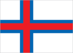
Description: white with a red cross outlined in blue that extends to the edges of the flag; the cross is shifted toward the left side in the style of the Dannebrog (Danish flag) meaning: white represents waves breaking on the shore; red and blue are traditional Faroese colors history: the flag is referred to as Merkid, meaning "the banner" or "the mark;" a group of students designed it in 1919, although it wasn't officially adopted until 1940
Ram
"Mitt alfagra land" (My Fairest Land)
Simun av SKAROI/Peter ALBERG
Adopted 1948; the anthem is also known as "Tu alfagra land mitt" (Thou Fairest Land of Mine); as a self-governing overseas administrative division of Denmark, the Faroe Islands are permitted to have their own national anthem
💹 Economy⬆️ Top
High-income Danish territorial economy; party neither to the EU nor the Schengen Area; associate Nordic Council member; very low unemployment; unique foreign ownership allowance in fishing industry; known salmon exporter; growing IT industries
$3.834 billion (2023 est.)
$3.741 billion (2022 est.)
$3.613 billion (2021 est.)
2.5% (2023 est.)
3.6% (2022 est.)
5.5% (2021 est.)
$70,400 (2023 est.)
$69,400 (2022 est.)
$67,800 (2021 est.)
$3.907 billion (2023 est.)
18.2% (2023 est.)
19.7% (2023 est.)
52% (2023 est.)
40.6% (2023 est.)
27.3% (2023 est.)
31% (2023 est.)
0% (2023 est.)
57.7% (2023 est.)
-56.6% (2023 est.)
Milk, potatoes, lamb/mutton, sheepskins, sheep offal, beef, sheep fat, beef offal, cattle hides, beef suet (2023)
Fishing, fish processing, tourism, small ship repair and refurbishment, handicrafts
4.1% of GDP (2023 est.)
4.4% of GDP (2022 est.)
4.3% of GDP (2021 est.)
$2.255 billion (2023 est.)
$2.219 billion (2022 est.)
$1.923 billion (2021 est.)
Russia 26.4%, UK 14.1%, Germany 8.4%, China 7.9%, Spain 6.8%, Denmark 6.2%, US 4.7%, Poland 4.4%, Norway 4.1% (2017)
Fish and fish products (2021)
$2.212 billion (2023 est.)
$2.223 billion (2022 est.)
$1.906 billion (2021 est.)
Denmark 33%, China 10.7%, Germany 7.6%, Poland 6.8%, Norway 6.7%, Ireland 5%, Chile 4.3% (2017)
Goods for household consumption, machinery and transport equipment, fuels, raw materials and semi-manufactures, cars
Danish kroner (DKK) per US dollar -
6.894 (2024 est.)
6.89 (2023 est.)
7.076 (2022 est.)
6.287 (2021 est.)
6.542 (2020 est.)
⚡ Energy⬆️ Top
100% (2022 est.)
99.9%
100%
180,000 kW (2023 est.)
463.285 million kWh (2023 est.)
25.115 million kWh (2023 est.)
53.7% of total installed capacity (2023 est.)
18.4% of total installed capacity (2023 est.)
26.8% of total installed capacity (2023 est.)
1% of total installed capacity (2023 est.)
1 metric tons (2023 est.)
5,000 bbl/day (2023 est.)
📡 Communications⬆️ Top
15,000 (2021 est.)
28 (2022 est.)
57,146 (2022 est.)
106 (2022 est.)
1 publicly owned TV station; the Faroese telecommunications company distributes local and international channels through its digital terrestrial network; publicly owned radio station supplemented by 3 privately owned stations broadcasting over multiple frequencies
.fo
98% (2017 est.)
19,000 (2022 est.)
35 (2022 est.)
🚚 Transportation⬆️ Top
OY-H
1 (2025)
12 (2025)
91 (2023)
Container ships 6, general cargo 45, other 40
9 (2024)
0
0
0
9
5
Fuglafjordur, Klaksvik, Kongshavn, Runavik, Sorvagur, Torshavn, Tvoroyri, Vagur, Vestmanna
🛡️ Military and Security⬆️ Top
No regular military forces or conscription
The Government of Denmark has responsibility for defense; as such, the Danish military’s Joint Arctic Command in Nuuk, Greenland is responsible for coordinating the defense of the Faroe Islands; the Joint Arctic Command has a contact element in the capital of Torshavn
Source: Factbook JSON archive.