No permanent inhabitants
 Coral Sea Islands
Key facts and a structured country profile. 🧾 Change log 📐 True Size
Locator 🗺️ Map
3 sq km less than
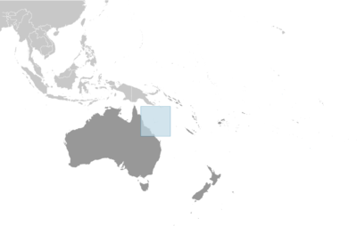
Oceania, islands in the Coral Sea, northeast of Australia
🧭 Background
The widely scattered Coral Sea Islands were first charted in 1803, but they were too small to host permanent human habitation. The 1870s and 1880s saw attempts at guano mining, but these were soon abandoned. The islands became an Australian territory in 1969, and the boundaries were extended in 1997. A small meteorological staff has operated on the Willis Islets since 1921, and several other islands host unmanned weather stations, beacons, and lighthouses. Much of the territory lies within national marine nature reserves.
🗺️ Geography
Oceania, islands in the Coral Sea, northeast of Australia
18 00 S, 152 00 E
Oceania
3 sq km less than
3 sq km less than
0 sq km
About four times the size of the National Mall in Washington, D.C.
0 km
3,095 km
3 nm
200 nm
Tropical
Sand and coral reefs and islands (cays)
Unnamed location on Cato Island 9 m
Pacific Ocean 0 m
Fish
0% (2018 est.)
100% (2018 est.)
Occasional tropical cyclones
Important nesting area for birds and turtles
👥 People and Society⬆️ Top
No permanent inhabitants
🌿 Environment⬆️ Top
No permanent freshwater resources; damaging activities include coral mining, fishing practices (overfishing, blast fishing)
Tropical
0% (2018 est.)
100% (2018 est.)
🏛️ Government⬆️ Top
Coral Sea Islands Territory
Coral Sea Islands
Self-descriptive name to reflect the islands' position in the Coral Sea off the northeastern coast of Australia
Territory of Australia; administered from Canberra by the Department of Regional Australia, Local Government, Arts and Sport
The common law system of Australia applies
See Australia
None (territory of Australia)
None (territory of Australia)
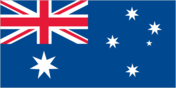
The flag of Australia is used
🛡️ Military and Security⬆️ Top
Defense is the responsibility of Australia
Source: Factbook JSON archive.