The Settlement (Flying Fish Cove)
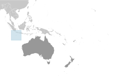
 Christmas Island
Key facts and a structured country profile. 🧾 Change log 📐 True Size
Locator 🗺️ Map
1,692 (2021 est.)
135 sq km
Southeastern Asia, island in the Indian Ocean, south of Indonesia
🧭 Background
Although Europeans sighted Christmas Island in 1615, it was named for the day of its rediscovery in 1643. Steep cliffs and dense jungle hampered attempts to explore the island over the next two centuries. The discovery of phosphate on the island in 1887 led to the UK annexing it the following year. In 1898, 200 Chinese indentured servants were brought in to work the mines, along with Malays, Sikhs, and a small number of Europeans. The UK administered Christmas Island from Singapore. Japan invaded the island in 1942, but islanders sabotaged Japanese mining operations, making the mines relatively unproductive. After World War II, Australia and New Zealand bought the company mining the phosphate, and in 1958, the UK transferred sovereignty from Singapore to Australia in exchange for $20 million to compensate for the loss of future phosphate income. In 1980, Australia set up the Christmas Island National Park and expanded its boundaries throughout the 1980s until it covered more than 60% of the island’s territory. The phosphate mine was closed in 1987 because of environmental concerns, and Australia has rejected several efforts to reopen it. In the 1980s, boats of asylum seekers started landing on Christmas Island, and the migrants claimed refugee status because they were on Australian territory. In 2001, Australia declared Christmas Island to be outside the Australian migration zone and built an immigration detention center on the island. Completed in 2008, the controversial detention center was closed in 2018 but then reopened in 2019. In 2020, the center served as a coronavirus quarantine facility for Australian citizens evacuated from China.
🗺️ Geography
Southeastern Asia, island in the Indian Ocean, south of Indonesia
10 30 S, 105 40 E
Southeast Asia
135 sq km
135 sq km
0 sq km
About three-quarters the size of Washington, D.C.
0 km
138.9 km
12 nm
12 nm
200 nm
Tropical with a wet season (December to April) and dry season; heat and humidity moderated by trade winds
Steep cliffs along coast rise abruptly to central plateau
Murray Hill 361 m
Indian Ocean 0 m
Phosphate, beaches
0% (2018 est.)
100% (2018 est.)
NA
Majority of the population lives on the northern tip of the island
The narrow fringing reef surrounding the island can be a maritime hazard
Located along major sea lanes of the Indian Ocean
👥 People and Society⬆️ Top
1,692 (2021 est.)
1,007
685
Christmas Islander(s)
Christmas Island
Chinese 70%, European 20%, Malay 10% (2001)
English (official) 27.6%, Mandarin 17.2%, Malay 17.1%, Cantonese 3.9%, Min Nan 1.6%, Tagalog 1%, other 4.5%, unspecified 27.1% (2016 est.)
Muslim 19.4%, Buddhist 18.3%, Roman Catholic 8.8%, Protestant 6.5% (includes Anglican 3.6%, Uniting Church 1.2%, other 1.7%), other Christian 3.3%, other 0.6%, none 15.3%, unspecified 27.7% (2016 est.)
16.6%
70.4%
13% (2021)
38 years (2021 est.)
1.11% (2014 est.)
Majority of the population lives on the northern tip of the island
🌿 Environment⬆️ Top
Loss of rainforest; impact of phosphate mining
Tropical with a wet season (December to April) and dry season; heat and humidity moderated by trade winds
0% (2018 est.)
100% (2018 est.)
🏛️ Government⬆️ Top
Territory of Christmas Island
Christmas Island
Named by English Captain William MYNORS for the day of its rediscovery, Christmas Day (25 December 1643); Europeans had sighted the island as early as 1615
Non-self-governing overseas territory of Australia
Non-self-governing territory of Australia; administered from Canberra by the Department of Infrastructure, Transport, Cities & Regional Development
The Settlement (Flying Fish Cove)
10 25 S, 105 43 E
UTC+7 (12 hours ahead of Washington, DC, during Standard Time)
Flying Fish Cove was named after a British explorer's ship in 1886
System is under the authority of the governor general of Australia and Australian law
1 October 1958 (Christmas Island Act 1958)
See Australia
18 years of age
King CHARLES III (since 8 September 2022); represented by Governor-General of the Commonwealth of Australia General Sam MOSTYN (since 1 July 2024)
Administrator Farzian ZAINAL (since 11 May 2023)
NA
The monarchy is hereditary; governor general appointed by the monarch on the recommendation of the Australian prime minister; administrator appointed by the governor-general of Australia for a 2-year term and represents the monarch and Australia
Christmas Island Shire Council
Unicameral
9 (directly elected)
Plurality/majority
Partial renewal
4 years
10/2023
Independent (9)
13%
October 2025
Under the terms of the Territorial Law Reform Act 1992, Western Australia provides court services as needed for the island, including the Supreme Court and subordinate courts (District Court, Magistrate Court, Family Court, Children's Court, and Coroners' Court)
None
None (territory of Australia)
None (territory of Australia)
None
None (territory of Australia)
Australia Day (commemorates the arrival of the First Fleet of Australian settlers), 26 January (1788)
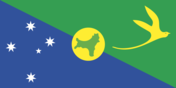
Description: territorial flag; divided diagonally from upper left to lower right; the upper triangle is green with a yellow silhouette of the golden bosun bird; the lower triangle is blue and shows the Southern Cross constellation, representing Australia; a centered yellow disk displays a green outline of the island
Golden bosun bird
"God Save the King"
Unknown
Royal anthem, as an Australian territory
💹 Economy⬆️ Top
High-income Australian territorial economy; development through government services and phosphate mining; operates Australia’s Immigration Detention Centre; increasing tourism and government investments; sustained environmental protections
Tourism, phosphate extraction (near depletion)
Indonesia 30%, USA 26%, Malaysia 12%, Ireland 8%, UK 7% (2023)
Fertilizers, paintings, amine compounds (2023)
USA 58%, Australia 40%, Malaysia 1%, Fiji 0%, Singapore 0% (2023)
Aircraft, refined petroleum, cars, air conditioners, plastic products (2023)
Australian dollars (AUD) per US dollar -
1.515 (2024 est.)
1.505 (2023 est.)
1.442 (2022 est.)
1.331 (2021 est.)
1.453 (2020 est.)
📡 Communications⬆️ Top
1 community radio station; satellite broadcasts of several Australian radio and TV stations (2017)
.cx
78.6% (2016 est.)
🚚 Transportation⬆️ Top
1 (2025)
18 km (2017)
18 km (2017) 1.435-m (not in operation)
1 (2024)
0
1
0
0
0
Flying Fish Cove
🛡️ Military and Security⬆️ Top
Defense is the responsibility of Australia
Source: Factbook JSON archive.