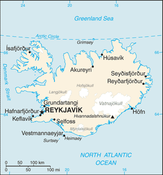
 Where Is Iceland Located?
Use this map to see where Iceland is located and jump to the full country profile.
What is the true size of Iceland?
Most online maps use the Mercator projection, which can exaggerate land area away from the equator. Use the True Size tool to compare Iceland at different latitudes and against other countries on the same projection.
Reported total area: 103,000 sq km. Population context: 364,036 (2024 est.). Geographic context: Northern Europe, island between the Greenland Sea and the North Atlantic Ocean, northwest of the United Kingdom.