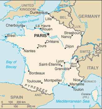
 Where Is France Located?
Use this map to see where France is located and jump to the full country profile.
What is the true size of France?
Most online maps use the Mercator projection, which can exaggerate land area away from the equator. Use the True Size tool to compare France at different latitudes and against other countries on the same projection.
Reported total area: 643,801 sq km ; 551,500 sq km (metropolitan France). Population context: 68,512,806 (2025 est.). Geographic context: Metropolitan France: Western Europe, bordering the Bay of Biscay and English Channel, between Belgium and Spain, southeast of the UK; bordering the Mediterranean Sea, between Italy and Spain French Guiana: Northern South America, bordering the North Atlantic Ocean, between Brazil and Suriname Guadeloupe: Caribbean, islands between the Caribbean Sea and the North Atlantic Ocean, southeast of Puerto Rico Martinique: Caribbean, island between the Caribbean Sea and North Atlantic Ocean, north of Trinidad and Tobago Mayotte: Southern Indian Ocean, island in the Mozambique Channel, about halfway between northern Madagascar and northern Mozambique Reunion: Southern Africa, island in the Indian Ocean, east of Madagascar.